
I had been led to believe that she was a Robert Tucker designed boat but none of the sketches of his boats really matched up. I recently ran across a photo that looked exactly like my boat, and began to follow the URL trail until I found real data about Waltzing Matilda (not by name/serial number)
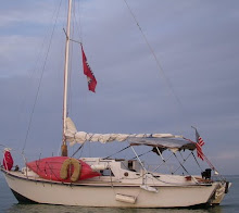
Medium displacement fibreglass / wood cruiser / racer
LOA 24ft 0in 7.3 m
LWL 19ft 0in 5.8m
Beam 8ft 6in 2.6m
Draught 2ft 9in 0.8m
Sail area 244 sq ft 22.7 sq. m
Displacement 1.85 tons 1900kg
Ballast 1000 lbs 454kg
I began to dig deeper and found her builder's history and discovered that she is considered a racing boat. I know that she was originally a twin bilge keeled boat and seeing the conditions the British owners harbor in I can see why, I am very happy with Waltzing Matilda being a single keel, it makes it easier to get her off the sand when we do run aground. All this information came from a group of Brits that sail together in Falmouth Gypsys, looking closely at their photos I could see that several of them had the same style rigging that I have, a couple had modified theirs to both cutter and yawl. I would love to put a bowsprit and another fore sail on, I've been thinking about it now that I have more sails and am planning to re-rig anyway.
I still want to head down to the Everglades before hurricane season really sets, and maybe cruise back through Key West, I've scoped and plotted a course and want to get that done soon, so I am working on raising some cash and re-stocking the boat with months worth of food. After Key West I will run back up to the St Petersburg area for the storm season.
I finally figure out how to follow the track my GPS makes in Google Earth, now you can play it too and see how close I anchored to shore, how deep the shoals that I ran over were and how slow I moved in 5kt variable winds, I posted the kml file in Google Docs, and I put more pictures up at Picasa
No comments:
Post a Comment